World Heritage Sites in Norway
Bryggen, the Old Hansiatic Quarter of Bergen
(60.397 N 5.324 E) --
satellite image
Bryggen, the old wharf of Bergen, had buildings on the site
before King Olav Kyrre gave Bergen city status in 1070 and was
the seat of the Hanseatic League of Merchants for 400 years beginning in 1360.
It is comprised of beautiful wooden houses that have been lost to
the city's many fires. The buildings were rebuilt after a devastating fire
in 1702 burned the entire city to the ground. The remnants of the
Hansa period's city structure is inscribed at a World Heritage Site.

Urnes Stave Church
(61.298 N 7.322 E)
The Urnes (sometimes spelled Ornes) stave church in Luster, Sognefjord, built in the second half of the
twelfth century, contains a 100 year older church doorway.
It is believed to be the oldest church of its kind.
A four-legged animal beset by dragons is the main motif on the jambs.
Røros Mining Town and the Circumference
(62.578 N 11.387 E) --
satellite image
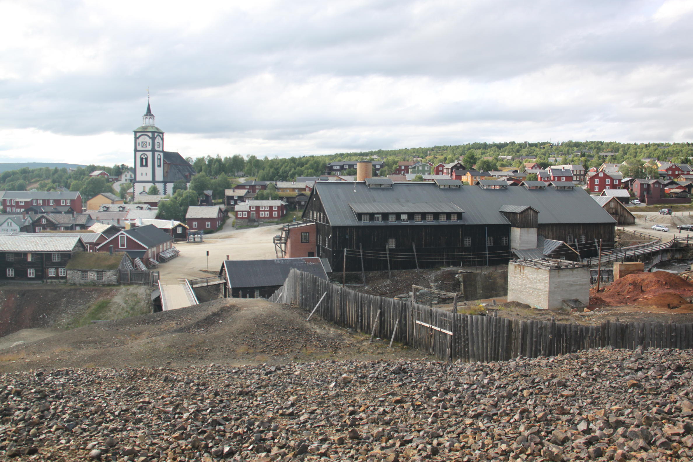 Røros is
an historic copper mining town with colorful
wooden houses in a picturesque setting.
Cooper ore was discovered in the Røros mountains
in 1644. Two years later, Røros Copper Works was
established and produced copper and sulphur pyrite until 1977.
The town, the Femundshytta smelter and the Winter Transport Route
have been included in the World Heritage Listing.
Røros is
an historic copper mining town with colorful
wooden houses in a picturesque setting.
Cooper ore was discovered in the Røros mountains
in 1644. Two years later, Røros Copper Works was
established and produced copper and sulphur pyrite until 1977.
The town, the Femundshytta smelter and the Winter Transport Route
have been included in the World Heritage Listing.
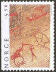
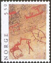
Rock Drawings of Alta
(69.948 N 23.187 E) --
satellite image
Alta has one of the largest known collections of rock carvings made by
hunter-gatherers and they went unnoticed until they were uncovered in 1973.
The rock art in Alta is between 6200 and 2000 years old.
They were made in the bedrock by hammer and chisel.
Vegaøyan - The Vega Archipelago
(65.78 N 11.95 E) --
satellite image
A cluster of dozens of islands centered on Vega, just south of the
Arctic Circle.
The islands are an example
of life based on fishing and harvesting the down of eider
ducks in an inhospitable environment which have been taking
place here for ten thousand years.
West Norwegian Fjords - Geirangerfjord and Naerøyford
(62.117 N 7.167 E) --
satellite image
The two fjords, among the worlds longest and deepest, are considered
as archetypical fjord landscapes and among the most scenically
outstanding anywhere.
Struve Geodetic Arc
(69.939 N 23.360 E)
Joint listing:
Belarus, Estonia, Finland, Latvia, Lithuania, Norway,
Republic of Moldova, Russian Federation, Sweden, Ukraine
The Struve Arc is a chain of survey triangulations running through
ten countries and over 2,820km (1752 miles) from
Hammerfest in Norway to the Black Sea.
The survey was carried out between 1816 and
1855 by the astronomer Friedrich Georg Wilhelm Struve, and
represented the first accurate measuring of a long segment of a
meridian. 34 of the original 265 station points are included in
the listing.
Rjukan-Notodden Industrial Heritage Site
(59.878 N 8.594 E)
Complex established by the Norsk-Hydro Company to manufacture artificial fertilizer from
nitrogen in the air. The company towns of Rjukan and Notodden link workers' accommodation by
rail and fery to ports where the fertilizer was loaded.
Back to the
World Heritage List
Lynn Salmon <>{
Last updated: May 6, 2021