Indiana Salmon and the Midwest Crusade
July 13-27, 2023

by Lynn Salmon <>{
by Lynn Salmon <>{
Indiana Salmon got started on her Midwest Crusade. I hit the road at 10am and headed for my first planned stop in the Tri-state area.
First, some background information. A good road trip needs some goals, a bit of an outline, a few must-see spots, and the flexibility to detour as whimsy strikes you. My three main target places to visit were: Rushville, Indiana; Collinsville, Illinois; and Wauseon, Ohio. The first is the place of my birth, the second contains a world heritage site, and that last one was the site of the Midwest Geobash Mega event.
Secondary goals included:

Main goals for the morning included finding a cache and visiting Sussex, a new-to-me county, in the top corner of New Jersey. While I'm at it I found a cache at JTs Knife Shop in New York, and then moved on to Pennsylvania for a tri-state trifecta. The NJ stop was a quick park-n-grab at the Tri-State Mall. Before arrival, I didn't realize it would be a ghost mall. I'm not sure which is creepier - looking for a cache in a tree of an active bank or at a dead bank. I found the cache and did an ebird list (3 house sparrows and a fish crow). I had planned to ebird in every county, but many of my stops netted nothing other than house sparrows, and I opted only to make ebird lists in interesting spots or when new species were seen.
I spent the rest of my day geocaching and visiting counties in Pennsylvania. It was a warm day and probably a mistake to spend a couple of mid-day hours hiking and looking for geocaches in Pike County Santos Riverfront Park. This area made it on my radar approximately 10 years ago when The Fibonacci Challenge cache was published. I love the Fibonacci sequence and am a sucker for challenge caches. There were also a dozen puzzle caches involving Pi in the area. Unfortunately, I struck out and couldn't find the first 2 Pi puzzles I searched for. I almost didn't find the Fibonacci challenge either. The area was severely overgrown with vegetation, including poison ivy and thorns, and despite being a stone's throw from the Delaware River, I couldn't even see the water today. And it was HOT and HUMID, and I found a tick on myself later at the hotel. There were some cool looking fields with a crop, soy beans perhaps, and this area would likely be very enjoyable in fall or on a mild winter day.
I made my way through more counties in Pennsylvania some previously visited, some new.
I passed through, but didn't stop in Monroe County, followed by a new county
visit in Carbon County where I stopped for a stupid geocache
in a McDonald's
parking lot. Continuing west, I passed through Luzerne and Columbia counties
before jiggling my route north a bit to add Lycoming County to my county list.

Near the Lycoming Mall outside Muncy PA was an interesting roadside attraction called the Hadany Arch. It's a cool looking, 100 foot tall, twisted steel arching over the road going into the mall. Made by sculptor, Israel Hadany. Definitely worth a quick stop, but would have better lighting for a visit in the morning. While there, I zipped around the deserted mall parking lot, found a couple of geocaches and got gas.
I had enough energy to stop for one more geocache. An easy-peasy virtual cache at the home of Little League Baseball International in South Williamsport, PA. I had no idea there was a such a gathering for little league players from all over, but as a girl, I never played, nor paid attention to such things. John may have known about it. The museum was closed, but all I had to do for the geocache was take a selfie at the spot to prove I visited. I learned that the first Little League game was played on June 6, 1939. Lundy Lumber beat Lycoming Dairy 23 to 8.


It was nearing 7pm, and I called it a night at the Hampton Inn in Williamsport. The room was clean and comfortable, and I exploded my belongings onto the spare bed and relaxed for the evening.

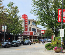
Williamsport: the birthplace of Little League and home to the Little League World Series, has many art installments located around the downtown area and beyond. These include the Bases Loaded Project bronze sculptures. While it was pleasantly cool and overcast in the morning, I walked around town and visited of few of these. The town hadn't woken up yet and the streets were pretty quiet.
My first stop was the Runner at 1st on 3rd Street. It was one-way the wrong way, so I ended up parking on 4th and walking back. I walked around a bit more photographing things, and headed toward a nearby geocache with a lot of favorite points. This took me through the bus depot where a mechanical voice was announcing buses to various places. One was going to the Jersey Shore, but it's a different Jersey Shore than the one nearer home. It was Friday morning rush hour with at least 6 people waiting for buses.
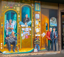
A geocache called Mike's Inspiration took me to an area with a large mural by artist, Michael Pilato (see link). This mural features notable people from Williamsport and Lycoming County, many sporting halos. I took a lot of photos that don't do it justice.


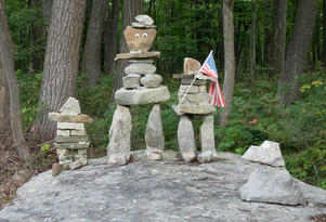
Back on the road heading west through Clinton, Centre, and Clearfield Counties. I found a nice cache at the Pine Creek Seed farm which turned out to be in Jersey Shore. The farm had some goats grazing nearby and offers a corn maze in the fall. I love corn mazes! Stopped at a few more geocaches including a cute one by a rock family randomly placed by the side of the road.
And then came Dubois. The car GPS pronounced it Do Boys - is that really how the people in town pronounce it? Do boys come to Dubois? I stopped in Do-Boys to look at the big eyeglasses on Main Street. I attempted to do an Adventure Lab that would take me on a historical tour of Do-boys. It started out okay outside the Historical Society, which was closed, but had interesting stuff in its window displays. Unfortunately, the next stop was at an abandoned house from 1903 in a trashy fenced off area that I decided to pass on. Needing a break, I stopped at a Dunkin but they were out of donuts. Got a coffee but the cup was defective and I dribbled on myself. Time to escape from Dubois, Do-boys.

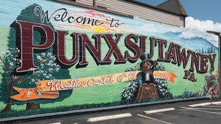

Next stop, Punxsutawney, weather capital of the world. Although I couldn't find
the geocache at the worlds largest Ground Hog statue, I did complete a nice
5 stage AL that took me to other ground hog sites around town. I ended up at
Gobbler's Knob where Phil does his annual weather predicting. One year I told
John we always celebrated Ground Hog Day, and he believed me. We celebrated
many times after that.

I next headed south into Indiana. Indiana County Pennsylvania that is. Indiana Salmon had to make the detour. I found 3 easy caches in Indiana County and almost hit a turkey that decided to run across the road. Ebirded it instead. I had a nice drive around back country roads passing many Amish buggies. It added considerable time to my day, but this is what vacation is about.
I continued picking up some additional PA counties including Armstrong, Butler, and Verango. It's after 7pm and I've been out and about for 11 hours so plan to stop for the night in Mercer County but miss the exit and end up just over the border in Ohio. There's a convenient Best Western and I enjoy a nice big room with a sofa and king size bed. Escaped from Pennsylvania!

Should I start with the guy that pulled a gun on me today or save that story for another time?
Let's begin with, CENTER OF THE WORLD. That's wahat the sign says. If you google "center of the world" it says Felicity California is the official center of the world. If you add "ohio" to the search term you learn:
Center of the World is an unincorporated community in far eastern
Braceville Township, Trumbull County, Ohio, United States. It
consists of several houses and a few retail establishments centered at
the crossroads where State Routes 82 and 5 diverge.

The community was founded by Randall Wilmot, an eccentric investor who had plans to make his new community a major economic center in northeast Ohio. When the railroads used the nearby city of Warren as the regional hub, Center of the World fell into decline both in terms of population and industry.
Who could pass up a visit to Center of the World. Not me. I was surprised there was not geocache at the sign. The closest one was a little down the road at a gas station, so I found that. And, I'm adding Trumbull County to my list.
About 15 minutes later, I caught sight of a swan as I was driving by the Leisure Lake Campground. After pulling over to take a closer look, I discovered it was a wooden decoy. There were some real geese, purple martins, robins, and other birds so I made an ebird checklist. No swans.
I find some ho hum park n grab caches along my route. One is at a McDonalds on Lynn Rd, so I take some selfies with the road sign. Another cache on a guardrail peaks my curiosity as it has several favorite points. It turns out to be the head of an old golf club with a hole drilled in it that holds a nano cache container. While the owner deserves credit for trying to do something cute, it ultimately just made the thing hard to find.
Now things get interesting. I'm nearing the degree of confluence at N41 W82. I learned about the Degree of Confluence project more than 20 years ago and can credit it for helping me discover geocaching. At that time, John and I eagerly visited the nearest confluence to us which was at N34 W118. We successfully made it up the brushy hillside to that spot and soon found ourselves covered with more ticks than I've ever seen. We ultimately fumigated the car and considered burning all the clothes we were wearing that day.
I visited another confluence after moving to NY. I trekked out to a geocache at N41 W74 in New Jersey. The approach was tricky, involved some swampland and mud, but I successful chalked up the find.
Naturally, I was intrigued when I saw there was a geocache at the N41 W82 confluence in Ohio. It looked like it would be easy. I pulled over and parked by the side of the road. The cache is only 175 feet away, but it is through a thicket of tall grass and scrub brush. Hmmmm. I check old cache logs to see if there is an easy approach and learn it is better to visit in winter :-). I decide to go for it any way.
I put on my tick gaiters and work my way toward GZ. A spider web plasters me in the face. Isn't geocaching fun. I got to within 20 feet when I encountered the neighbor with a gun who asks me what I'm doing. I explain about geocaching, and he decides I'm harmless and stuffs the gun in his waistband. However, I get the hint that I should take my leave and give up the search for this geocache. He kindly let's me go through his yard and walk back to my car on his driveway to avoid the Bushwick back. This geocache has been here for 16 years with 615 finders, yet I'm the first one to encounter the neighbor. I note the experience in my DNF log on the cache page.
Shifting gears, I head toward Waldo. Where's Waldo? I think it's near the town of Lynn and my route takes me through Ashland, Richland, and Morrow Counties. In the end, I didn't make it to Lynn, and I had some trouble finding Waldo.


There was a street fair in Waldo that closed and some roads were closed to cars. I had planned to visit an AL in the area, but could only axcess 2 of the 5 stages on the edge of town. But, I was able to find Waldo's Weenie, a geocache in a nearby park, and a geocache at the 911 memorial at the Waldo Fire department.
It started raining on my parade. Over all I was very lucky with weather on this trip with mostly clear weather, but this afternoon included a heavy downpour for about an hour. I curtailed my plan to zig zag through some other Ohio counties and got on the I70 heading west toward Indiana in the rain saving a couple of hours of driving.
Ohio had a big sign saying I was leaving, but I didn't see anything from Indiana welcoming me home. I stopped at a geocache called A National Road Welcome. It was welcoming me to the Cumberland Road, which was America's first interstate highway. A fitting stop for a road trip, and the cache was inside in a large treasure chest.
It was an hour further to Rushville, and my hotel. The hotel, called The Quality in near Amish Country, was the only one available in Rushville. It was absolutely fine. The woman working was finishing up a 12 hour shift, but despite being tired, she was friendly and showed me two possibe rooms which seemed identical. I chose the second one and settled in for the eveining.
It's my birthday, so what am I going to do all day? Geocaching, of course. Though, I probably could give the same answer for most any random day of the year. If in doubt, go geocaching. But first, I'll have a waffle for breakfast.
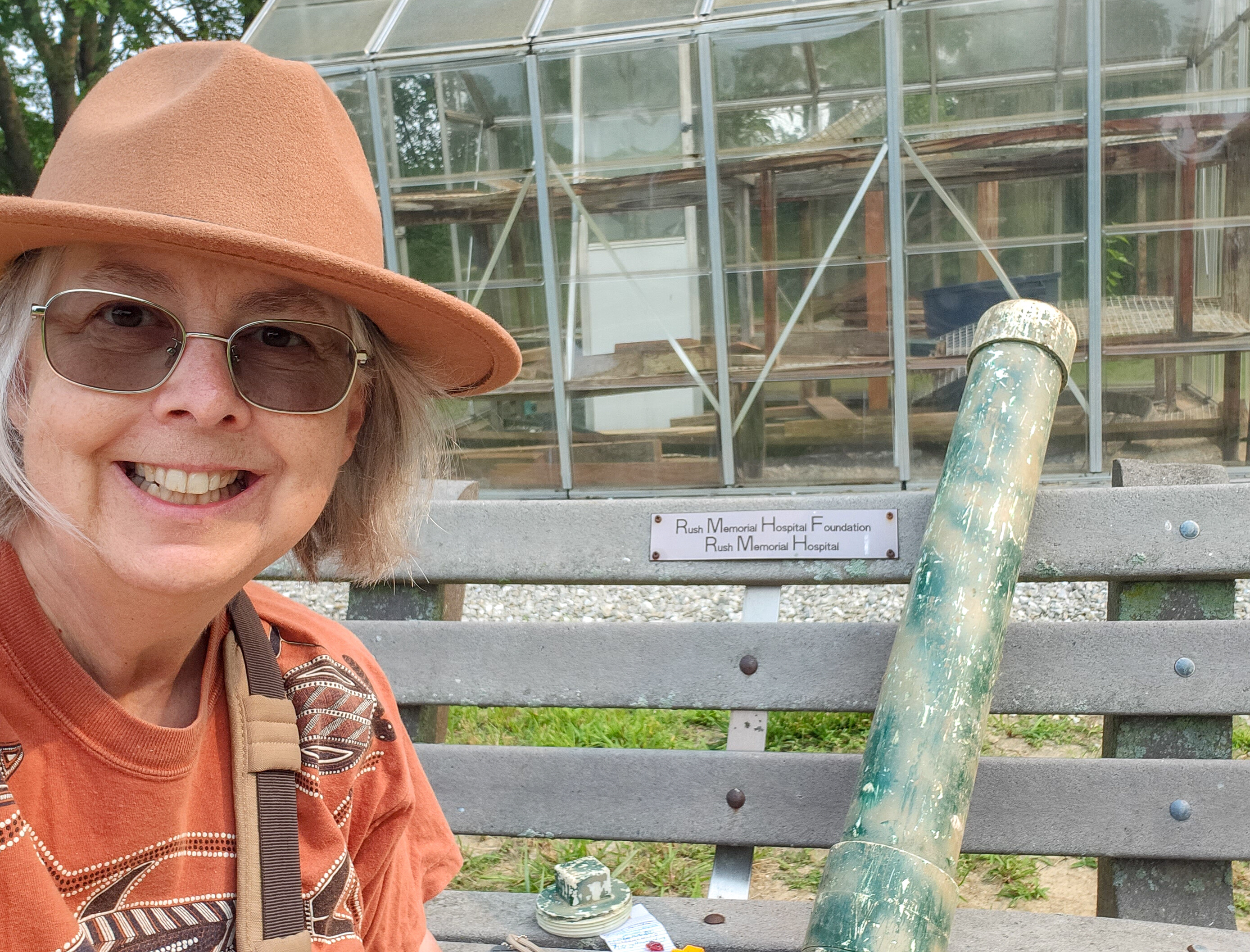
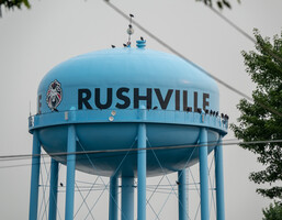
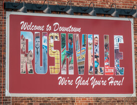
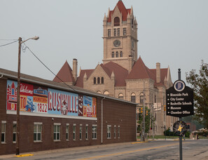
As I was heading out, I noticed RUSHVILLE in great big letters printed on the water tank above town and drove around a bit to try and photograph it and me and my birthday card. Most of the selfies looked like crap, but I got some shots of the mumu-mobile about town, plus the 22 turkey vultures posed to wish me a happy birthday from on high. And, I drove by the place of my birth, Rush Memorial Hospital and noted the blinking display that alternated between Pediatrics and the time-temperature.
Rushville has always been an enigma for me. It's the place of my birth and thus written on my passport and all sorts of other documents pertaining to me over the years. Yet, until yesterday, I'd never actually "been" here before. My parents lived here temporarily for perhaps as long as a year. I'm not really sure. My mother mentioned it being really hot the summer I was born. I think she may have been bored out of her mind having given up her "career" for the white-picket-fence life. My father was an electrician at the time. He was putting up some type of towers for Western Union.
As I looked around town I imagined things that might have been here when my parents lived here. The Princess Theatre on main street opened in 1915. They must have seen a movie or two there. Alas, it wasn't showing the new Indiana Jones movie this week. Or perhaps they bowled at the Rushville Bowl. It opened the year I was born.


My first geocaching choice for the day was GC5C7JW at the Kuhn Nature Center. It was a perfect choice, a great big container in a lovely garden setting. There were a couple of birthday bunnies loitering on the grounds along with a few birds. No people around, until after I spread out all the cache goodies on a bench and started taking silly selfies. A woman walked by, smiled and said hello to me. And she doesn't even know I'm the lady with the polka dot car.
I made a couple of quick caching stops around town and then concentrated on some nicer spots including some caches at the East Hill Cemetery where Wendell Willkie is buried. I sat at a particularly peaceful bench in a back corner where I heard a Brown Thrasher calling and took some nice photos of the bird. A nearby niche had some names that included my mother's first name on one, and her last name on another. A great spot for quiet contemplation.
I did a bit of driving on narrow country roads passing little but corn fields. I headed east to pick up Fayette County, and then south to add Decatur county to my visited counties list. I was driving around 25-30mph before I noticed the speed limit on these roads is actually 55mph!
The Library Limestone Earthcache helped me learn why Indiana limestone is one of America's prized building materials. See this Smithsonian link for more info.
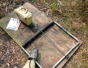


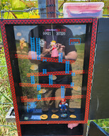
After a short afternoon "siesta" back in my room, I headed back out caching around 4pm. It's light until well after 9pm this time of year, so I have plenty of caching time available to me this evening. The plan is to head west about 20 minutes to Shelby County, and then work my way back to Rushville caching along Route 44. There are a string of gadget caches along here with many having favorite points in the 100s. One of my favorites was GC5K7X3, Will the Mouse take the cheese? This gadget cache features a giant mousetrap with a yellow ammo box as the bait.
I got the cheese, along with another dozen or so of the caches which varied greatly, but all showed great creativity. One was a pipe center-mounted on a pole. The cache was inside the pipe, and you got the container out by spinning the pole and letting centrifugal force work its magic. The cache was called "watch out for flying objects" and you had to watch out to see which direction the container went flying and go find it.
I ended my caching day on that high point and enjoyed a shrimp tempura bento box from a Rushville Japanese restaurant called Sakura. There had been a Sakura Restaurant near us when we lived in Pasadena that John and I ate lunch at once a week or so. Happy birthday, Indiana Salmon.
At check out, if no one had been at the counter, the typcial state all weekend as I came and went, I would have dropped my key and left. But, a guy was there so I "checked out". It turns out I had never been checked in and had been marked as a no show. He called the woman who was working on Saturday night, then handed the phone to me. I'm not really sure why. I said hello and asked if she remembered me. She said yes and I gave the phone back to the guy at the counter. He started in on what seemed like it might be a lengthy lesson on how to properly check guests in, but he waived me on and I didn't have to wait for the poor women to be chewed out.
Alas, I didn't get to the world's biggest ball of paint at N40 15.531 W85 42.545, an hour north of Rushville. Maybe, next time. Instead, I headed NW through Hancock and into Marion County, skirting the city of Indianapolis. Unfortunately, my chosen route along state road, or is it county road, 52 was under construction on and off for miles adding unwelcome delays to my drive.
I cached my way through Indiana finding a handful of simple caches and picked one called Leroys Fish to be my milestone #8300 find. I was expecting something bigger, but was happy with the find. I think I've used this exact model rubber fish in one of my fish-themed geocache hides. It took some searching to find it, but it was worth it in the end.
I checked off Henricks County, followed by Morgan, Putnam, Clay, and into Vigo. Vigo County has the city of Terre Haute - birthplace of the Coca-Cola contour bottle. Woo hoo!


Somewhere in the back of my mind is a memory I can't quite recall that has something to do with Terre Haute. I saw a cool looking mural about the Coca-Cola bottle as I drove into town, but I don't think my foggy memory has anything to do with that. There are 3 different intersecting Adventure Labs in Terre Haute and I hope one of those might jog my mind.
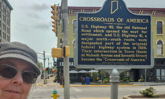
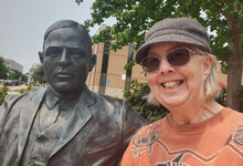
First I stop at the Crossroads of America. Not quite as good as the Center of the
World, but a close second. There's a bench next to the sign and I sit down
to cozy up to Max Ermann. He was a writer, poet, attorney, and snippets of his Desiderata
are engraved on the walkway. I also drive by the Clabber Girl Museum, Eugene Debs
house, and a Larry Bird Statue. While I'm slightly familiar with all of these
things, none of them relate to that Terre Haute memory that is still eluding me.

Just over the border into Illinois I stop at a rest area which has a Fancher Pony Truss Bridge. This bridge was designed and patented by the Trout brothers! Their unique design used round pipe in the top chords and there were 150 or so of these bridges built around Shelby County in the late 1800s. The one at the rest stop in Clark County Illinois had been in place for 88 years from 1895 until 1982 when a portion of it was moved to its rest stop location for preservation.
I next head for the Worlds largest Rocking Chair in Casey, Ill., the little town famous for big things. Later in my trip I visit the "large" rocking chair in Ashtabula. The one in Casey is definitely bigger, though the Ashtabula one is more fun since you can climb on it.
As I pull into town, I see the chair from a few blocks away and head toward it. The place is hopping with activity and I park next to the "very big, but not biggest yardstick". I like that one better than some of the other "biggest" items in town. But my favorite was of course the worlds biggest mouse trap.
One of the big things was the Worlds biggest teeter totter. Some people were jumping on it but it didn't teeter or totter. Probably a safety issue. The worlds biggest wind chime was quiet. The world's biggest barber pole, golf club, and bird cage all left me a bit flat. I would have liked the bird cage better if I'd climbed in and swung on the swing.


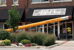
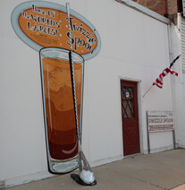
And then there was the world's biggest swizzle spoon. Huh? It was down a side street by itself, and wasn't even that big. The world's biggest mailbox was very big, however. The little town of Casey was well worth the detour, and it added Cumberland to my county list.
I crossed into a new time zone and it's an hour later for me than the clocks say. No wonder I'm so hungry. I pick a random cache in Effingham County near some fast food places and I got an Arby's. I was really hungry and it was quick.
I made one more stop at for a geocache at the Vandalia dragon in Fayette County. A woman saw me poking around as I was putting the container back in the dragon and she told me she knew where the tokens went. Evidentally you can buy tokens and make the dragon breathe fire. This is better done at night, and she was saving her tokens for after dark.
I continue through Bond County and into Madison County where I reach my destination for the next 3 nights at the Drury Inn in Collinsville.
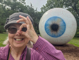
Be Seeing You. While strolling through Laumeier Sculpture garden, I was reminded of the giant ball in the 1960's tv show, The Prisoner and the "be seeing you" gesture which fit with the giant eyeball.
I've never visited the state of Missouri, and noting that it was only about 20 minutes away from where I was staying in Illinois, my main goal for the day was to head over and tick that state. I think that leaves only 5 states left unvisited for me.
I drove through St. Louis and saw the famous Arch from the car. But, I'm glad I chose Laumeier Sculpture Park as my main destination. It was awesome. It's a large place, 105 acres, with hiking trails and "my kind of art" all over the place. There were a couple of geocaches and 6 different Adventure Labs with 5 stages each, plenty of sculptures, and even some birds to enjoy. I tried to take it all in and capture a little bit with photos.
Dominating the landscape was Alexander Liberman's, The Way made from 18 salvaged steel oil tanks and painted a bright Cadmium red. I particularly liked how there was a miniature model of the sculpture with the description signage.

I spent my morning at a nearby ebird hotspot, The Horseshoe Lake State Park. After spending a few hours searching for an elusive Little Blue Heron near home last month, it was really cool to see about a dozen of them milling about in the marsh as I drove in.
I subsequently took a loop walk through the fields that was a bit longer and hotter than expected. I found a few geocaches, but the trails were also really birdy. It was pleasing to see several Dickcissels and a yellow-breasted chat conveniently posing close to me. There was also a very pretty blue butterfly I id'd as a Pipevine Swallowtail.


And who could pass on one of Collinsville's main attractions.
It's hard to miss the
World's Largest Catsup Bottle, though it's
hard to find a good vantage point to look at it. It was originally built
the whimsical structure as a
100,000 gallon water tower for plant operations of the W.E. Caldwell Company.
The company moved to Indiana, but a catsup bottle preservation group saved it from
demolition and it has become a historic landmark and roadside attraction.
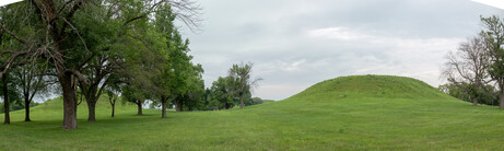
Cahokia Mounds World Heritage Site

Cahokia Mounds was added to the World Heritage List in 1982 when there were still less than 150 places on the list, so I would expect this to be one of the "good" ones, and it has generally been on my list of places to visit for at least 30 years. I chose Collinsville as my base of operations for 3 days so I would be nearby and could make multiple visits to Cahokia as the weather dictated my itinerary.
Cahokia Mounds State Historic Site preserves the largest prehistoric Indian city north of Mexico. It was designated as a World Heritage Site for its significance in the prehistory of North America. The city covered about 4000 acres and had around 120 mounds. It was inhabited from AD 700-1350. The State of Illinois preserves the central section of the city, 2200 acres, and 72 of the 80 remaining mounds. At its peak the city had a population of 20,000 people. They were farmers, craftsmen and traders. Long-distance trade from other villages brought sea shells from the Atlantic and Gulf Coasts, copper from Lake Superior, mica from the southern Appalachians and chert, salt, minerals and other goods from the Midwest.
I spent a couple of hours at the site on my first afternoon. I was pleasantly surprised by the site. I had expected the mounds to be small lumps in the grass like some other sites of this type I have visited. But it was much more expansive and impressive. There were many miles of trails to explore, excellent signage, and more geocaches than you could shake a stick at.
I began at the closed interpretive center for the start of an Adventure Lab and an earthcache. The AL took me through the Grand Plaza with visits to the Twin Mounds, Mound 72, the South Stockade, and the native garden and provided some useful background information.
There were only a handful of other visitors on the property, and I had the place virtually to myself. I found 3 of the 20 or more geocaches which each required a bit of a bushwack off trail. It was a hot afternoon. There was a brief downpour while I was ducking under some bushes looking for a geocahe. The rain quickly subsided and I decided I was more wet from sweat than rain, at that point.
I visited Cahokia a second time the next day and toured a different section of the site. I began with Monks Mound aka The Birdman's Home. The leader's home was on top of a flat-top mound, which is 100 feet high and covers 14 acres. There were a lot of steps going up to the top, some "joggers" were getting their cardio by using the stairs, and a school group was slowly making its way to the top.
Little is known about the people, but it is believed that hawks were messengers to the leaders from the Great Spirit. The hawk was portrayed in their artwork, and a sandstone tablet found on Monks Mound portrays a man wearing a hawk shaped mask and feathered cape.
I found 3 more geocaches on day 2. They weren't as bushwacky as yesterday's and led me through a grassy meadow where I heard and some meadowlarks calling and managed to get the camera on them. I also spotted a raptor flying over that might be a Mississippi Kite.


Up early, coffee, breakfast, and hit the road a bit after 7am as it started to sprinkle. With the rainy weather, I skipped some planned cache stops. Today was primarily a transit day as I head toward my next main target, the Ohio Mega Cache event.
After a simple park-n-grab at a closed hotel on Route 66 with a Big Boy Statue, I headed to Normal. What could be more normal than stopping for some geocaching in Normal? It seemed like a good idea in the planning stages. I picked a nice easy virtual for my main target, but Normal was a bit larger than I anticipated, and I drove some distance through this college town before getting to the Old Normal Theater. And, as I attempted to take a photo of the theater, my camera lens decided to fog up from the humid outdoor air as I stepped out of the nice air conditioned space in the car.


Normal is not finished having fun with me yet. Seeing that I parked a block away from an Adventure Lab that appears to have all 5 stages within a traffic circle I decided to take a short walk and do that, but have a lot of difficulty and I end up going in circles before giving up and heading onward. Even my quick stop to get gas on the way out of town is thwarted by Normal's Sam's Club. I guess non Sam Clubbers can't get gas at a Sam's club gas station and I had to backtrack to find another gas station.
I headed NE toward Kankakee because I liked the name of that town. After a stint on the I55, I spent much of my cross state drive on a two lane road with farm fields on either side. A very straight road with a 55mph speed limit. I set cruise control so I wouldn't speed, and of course any car that came up behind me had to pass me. There were only 2 such cars. Not a lot of traffic on this road.
I pulled over in the middle of no where for a cache called Millard Fillmore. I thought I would be at a memorial or marker or something, but it was just a pill bottle shoved in a guard rail. At least there were some meadowlarks and dicksissels calling in the field next to me.
Next stop Kankakee. Already? I did leave early and skip some planned zigging and zagging, but I ended up at my hotel at 3:08pm. I could have gone farther, but decided it would be nice to just stop and rest. It's in the upper 80s outdoors and a bunch of hot afternoon caching stops on the road isn't going to do anything for me. I find a couple of random geocaches in Kankakee, and visit a large flower pot listed as a Roadside Attraction, but it's not very large nor worth a stop.

Up and on the road at 7:15am heading east again, I was out of Illinois in a blink of an eye, spent most of the day in Indiana, stepped foot in Michigan, and ended up in Ohio. The plan is to drive on "back" roads picking up some unvisited counties in Indiana. These roads are long, narrow, straight, and posted for 55mph. I did a couple of short stretches on dirt roads, but possibly not until reaching Michigan.
 At a morning stop for caching in Roselawn Cemetery I chanced upon some
unidentified woodpeckers that turned out to be juvenile red heads!
They didn't yet have the distinctive red heads, but one of their adult
companions, Mom?, did.
I also stopped for a series of "along the way" caches, mostly little tubes
on signs, named for types of bacon
(example).
At a morning stop for caching in Roselawn Cemetery I chanced upon some
unidentified woodpeckers that turned out to be juvenile red heads!
They didn't yet have the distinctive red heads, but one of their adult
companions, Mom?, did.
I also stopped for a series of "along the way" caches, mostly little tubes
on signs, named for types of bacon
(example).
I happened to notice an Adventure Lab nearby in the Sandhill Crane Migration Area. Must check that out. I knew the cranes wouldn't be around at this time of year, but there were many other birds. I added a Henslow sparrow to the trip list, and also heard a Bobwhite, but couldn't see it. I did the 5 stages of the AL which took me on a shaded walk to a platform overlooking a big field. A very nice spot, thouroughly glad I stopped.
Then I looked for a cache at a billboard. It had a bunch of favorite points. No idea why since I couldn't find anything, unless you count the little snake under a rock. It was a real snake, not the cache. It ran away after I removed its protective rock.
To make up for the billboard DNF, I backtracked to a cemetery to find a cache in the same county. I had picked out the highly favorited billboard to represent Starke County but the cemetery had to do. That turned out to be a cache with bad coordinates, and I had trouble finding it too, but succeeded after reading old logs.
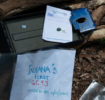
Next, a long drive to Elkhart Indiana to visit Indiana's First Geocache, hidden on 10-23-2000 and still in place today. While it technically was "on the way" to the Ohio Mega event which is my next destination, it proved much more difficult to get to than anticipated. I'm not sure what the traffic problem was in Elkhart, but I ended up in stop-and-go traffic for no apparent reason.


My next stop was much better. I visited the tri state marker for Indiana, Michigan, and Ohio. John and I used to always make these types of detours for interesting geographic markers. This one is significant for me -- born in Indiana, went to school in Michigan, and headed to the geobash in Ohio!
A couple on a motorcycle rolled up while I was there. They were specifically there to visit the tri-state marker and hadn't heard of geocaching. They offered to take my picture which enabled me to be in all 3 states at once. That selfie would have been hard to do by myself. There was also a physical cache nearby and an Adventure Lab with 5 stages.
On to Wauseon, Ohio and the Holiday Inn. The beds are not at all comfortable, and I had a few other small issues with the hotel room inclding problems with the bathroom door. But, it did give me an opportunity to use the string which has been a staple of my travel gear for many years. Note to self - avoid Holiday Inns and stick with Hampton, Drury, or Best Western hotels.

I woke up at 5:30am and went to breakfast as soon as it opened at 6am. Alas, the hotel does not have a waffle maker and its pancake maker is "out of service". Another strike for Holiday Inn. I also couldn't get the AC fan to turn off in the night and had to unplug the unit, and subsequently my door lock had issues, but enough complaining and on to the Mega Event!
I'm staying in Wauseon Ohio specifically to attend the Midwest Geobash 2023. It's the 15th year of this particular mega event, and I've heard it was a good time from other cachers in the past. I'm not quite sure what to expect. The event listing has it begin at 12:00 am this morning, yet the campground has been open for the 3 nights prior, and many people stay around for multiple days.
I arrived around 9:30am to a mostly sleeping fairgrounds, parked, and began figuring out how to get started. The nearest cache to my car was 170 feet away, and that seemed a likely target, but after walking over to it, I discoved the container was mounted on the other side of the fence. There is a roadway circling the fairgrounds, and a bunch of physcial caches are placed along there. You can drive, bike, or walk around to them, which I did later in the day with my car.
There was also an AL stage in this same vicinity. I was supposed to see stars, but didn't. A few other people showed up looking for the stars, and together we spotted them. I spent the next hour or so doing a couple of the Adventure labs with them. It was a good choice to work with others since the ALs had stages with puzzles or clues to work through. I particularly liked one stage a small darkened room. Once you found the UV flashlight you could get the answers that were painted on boards around the room. There was also a cute pacman themed puzzle with morse code filling in the pacman tracks. And a group of so gathered at the "tetris" stage was really necessary to work out that tough field puzzle. I believe that tetris puzzle was set up by a local tri-state cacher and I got to revisit it at a more local event in August this year.
I parted company with the Ohio cachers group and I spent the rest of the day solo caching. There were many more Adventure labs set up around the fairgrounds space. Several of them had multiple stages you could do in one spot with multiple choice answers that just required guessing. Not much point in those other than to rack up silly geocache finds. And, I had 103 finds on this day thanks to a number of these.


The "real" caches placed around the fairgrounds roadway, on the other hand, were fantastic. Most had very creative containers. Some you had to figure out how to open the log sheet containers, others were just very cool to look at. I left a mumu signature fish in the Donkey Kong themed cache. I remember John prounouncing it "dunkey kong". This one was for you, my love.
I stopped at the info center around noon, signed the log book, and took a couple of photos. I did one more cache before leaving called Frogger. You did have to dart across the road to get to the cool container and figure out how to open it. It seemed that everyone visiting it had stuffed their travel bugs inside, and a bunch fell out as I opened the container. I grabbed a handful to take home and add miles to them.
After lunch, I spent my afternoon caching around town, targeting geocaches with high favorite points. Some caches get favorite points because they are really cool, others because they are visited a lot. The Wauseon caches are a bit of both, with over a 1000 attendees at this mega event, a lot of them hit the local caches, and the locals try to put out some creative finds.
My favorite finds included
I also did a bunch of the local town Adventure Labs requiring much hither and yon as I would discover I drove by one stage or another AL as I was doing a different AL. But, these ALs included some nice historic spots around Wauseon. Other than some other strange people wandering around staring at thier phones and occasionally exclaiming, "found it", Wauseon seemd to be closed for business on a Saturday afternoon.
So was the Mega event worht it? Definitely for the few hours I spent since I was conveniently driving near on my way home. I can't imagine staying here for 4 nights camping. And, definitely give the nearby Holiday Inn a miss.
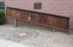
I remained in Wauseon for an additional day and began with a visit to the 911 Memorial at the fairgrounds. This led to coordinates for an offset cache located across the street from my hotel. I had to visit that in John's honor.
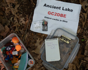
Next I set out toward Ancient Lake, the oldest active cache in Ohio. On the way I stopped by several EGG "challenge" caches. These had cool ideas behind the challenges, but were otherwise ho-hum guardrail hides.
I eventually arrived at the parking coordinates for the Ancient Lake. No lake in sight, however. But, the start of the walk was surprisingly birdy. I took photos of a towee and a red-headed woodpecker and heard a couple of my favorite pileated woodpeckers in the forest. I found the geocache easily on a nice 1.5 mile round trip hike.
I drove into Michigan, only 15 minutes north to pick up Lenawee County and then headed back to Wauseon for a leisurely day of geocaching around town until afternoon thunderstorms rained on my parade.

Another hotel breakfast with bacon and a veggie omelet. Vegetables have been few and far between on this vacation :-). Thanksfully, it's my last day at this Holiday Inn, the worst hotel of my entire trip. I was able to MacGuyver my own coffee pod refill for the Keurig with a foil lid of a yogurt container, which pleased me. (silly photo)
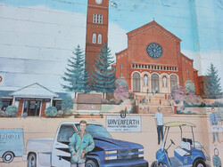
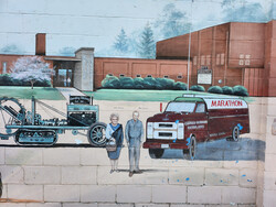
A few geocaches mark my visits to Henry and Putnam Counties including a stop in Kalida. It's a one traffic light kind of town and, of course, someone put a geocache at that light. As I stop and feel around for the container I realize that all the passing cars have to stop at this light and are probably watching me. I also walk around a bit for a Kalida Adventure Lab which takes me to a cool looking mural on the wall of the Kalida Market.


Onward now toward Lima, Ohio, hometown of my friends, The Fentons. Heading into to town driving south on West North Street. I visited the famous Kewpee Hamburger joint downtown among other notable spots in Lima.
The Lincoln Park Railway exhibit had a nice outdoor display with red buttons with audio information. I pushed a button and sound came booming out from speakers the whole neighborhood could probably hear. I was there alone at the time. Imagine if multiple people were pushing multiple buttons, though!


I also went to a nearby park called Ottawa Metro Park Lima Lake. It was lovely, and if it hadn't been 85 degrees out, I would have enjoyed it more. I found a couple of geocaches and took a lot of photos of trees in Evans Arboretum.
I headed east out of Lima picking up Hardin, Hancock, and Seneca counties passing through the town of Findlay, then Fosturia, and ending the day in Fremont, Ohio. The Hampton Inn is a big improvement over Holiday Inn.
I spent the day in Ohio starting in Sandusky County and heading north to tick off Ottawa County while visiting the Ottawa National Wildlife Refuge which is next to Magee marsh, my next stop. The Ottawa bird wildlife preserve had a Virtual Geocache appropriately named "Big Bird" which got me out of the car for a walk to find it along with some real birds. I ebirded 21 species including 3 Trumpeter Swans and several purple martins.
I heard about Magee Marsh earlier this year. SMRA took a trip there in May, but I didn't go. May is the busy warbler migration season when the parking lots are full and the board walks standing room only. Not so crowded in July. Mine was the only car in the lot, and I had the place to myself. Of course, there are also fewer birds. I ebirded 23 species, but it was a lovely leisurely bird walk for me. And the visitor center has an awesome duck room exhibit, too.
After a full morning of birding, I drove with a goal of picking up Hardin County. It had a cache in it called the South Pole. I liked the name better than the cache. I then returned to the OH2 or whatever main thouroughfare I was driving on and stopped at a rest stop that had a lovely 0.2 mile trek on a trail in the woods to a much nicer geocache.
Feeling rejuvenated, I drove through Cleveland. I planned to stop at an interesting looking sculpture garden, but couldn't find a place to park. Frustrated by city driving after my many days of quiet country roads, I just grabbed some fast food and continued on to the town of Chardon for a virtual cache at a church and an Adventure Lab that took me on a pleasant tour of the town square.
I stopped for the night in Ashtabula, home to a large rocking chair. Not the largest in the world, which I saw earlier on this trip in Casey, IL. Yes, it is a pretty big rocking chair at 20 feet tall. It is bigger than a breadbox, but I could build a bigger one in the back yard if I really wanted to. But, the rocking chair is only 2 minutes from my hotel, an easy visit, and there was a geocache at it.

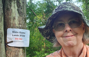
I drove about an hour to Game Lands 109 in Pennsylvania to look for the oldest active geocache in the state which is near a confluence point of N42 W80. It's in a swamp. I knew this going in, but reading past logs made it seem like there was a dry way to approach. Well, not today and not for me.
The walk began easily down a flat former road that is now a trail. It was very birdy and I heard, then saw some swamp sparrows (very appropriate location for swamp sparrows) and many red-winged blackbirds. The cache is only 0.3 miles from parking. I continued down the road/trail to a spot about 175 feet from my target where the tall swamp grasses looked trampled. This must be the way in. About half a dozen steps and I find my left foot is ankle deep in water. There are some logs that other people have placed down as an attempt to stay dry, but I don't want to risk a fall or sprained ankle and simply sludged ahead. A couple of steps had water up to mid-calves, so my boots and socks became wet and squishy.
Somehow this was great fun, and i made it to the cache and found it in the crook of a tree. Took a bunch of photos and then slogged my way back to the car. Fortunately, I have all my stuff with me and was able to change my pants, socks, and shoes. Good as new.
Moving on, I head east mostly on the 86 picking up conties I haven't visited, or haven't geocached in NY. My first stop is Chautagua County. I chose a virtual cache at a visitor center. Easy Peasy. There is also and Adventure Lab at the location, and I'm surprised to learn that it is indoors. But, it is in the visitor center and I take some time to hunt around for all the the stages.
Next, Cattaragus County. This proved harder than expected. I picked out a cemetery cache called something like peaceful place about 10 minutes detour from my route. Pleasant drive, cache is somewhere near the entrance gate. I hunt around a little, and a car comes in. I pause until they pass, but they stop with a direct eye-line to my hunt area. I feel uncomfortable, and disrespectful continuing to look and give up on this geocache. Normally, I find cemetery caches very peaceful and relaxing, but only when I have the place to myself.
Really wanting to find a geocache in this county, I head back to where I got off of the 86 and find a silly cache in the parking lot of an Indian casino. The casino also had an Adventure Lab with 10 stages which took some back and forth on my part to complete. Probably causing the valets to wonder what this car with the polka dots was doing. I did a couple more caches and noticed the area stop signs were in two languages, English and the language of the Seneca nation.
Next visit: Allegany county. I targeted the small town of Angelica and found a little cache next to the library and did the AL around the town circle. It had a cute old-timey post office. I subsequently stopped at a "text stop" only to learn that text stops don't have restrooms. It did have a geocache, however. I was standing near the location looking around as some guy driving by asked if I was looking for "the little thing". I said yes, he said he didn't know what it was but it was on the sign. It was. It was a nano hiding in plain sight.
Steuben County. I tried to find two supposedly simple caches both with the hint, "HIPS". I don't know what HIPS means and I couldn't find either. Tried to find the next closest cache. It was in a playground. Coulnd't find that either. One more try, another playground cache. Did find it, but felt like I had to search too near the trash. The town was named Bath. I fell like a need a bath after my visit.
Next stop, another cemetery cache in Chemung county. The hint is "HIPS". Not this guy again!!! But, at least I was all by myself in this cemetery and could scour the signpost without feeling suspicious. The cache turned out to be a nano hidden inside some kind of screw thingy with a chain attached. Perhaps some type of climbing gear. I still don't know what HIPS stands for. And, I dropped the cap of the nano and couldn't find it in the grass. Not having a lot of cache success this day!
I'm tired. It's 5:30pm. I check the Hampton Inn app on my phone and found the nearest room for the night. The internet is flakey. First time with a problem on the trip. I can stream Netflix, but can't reach geocaching or Chase bank. Hmmm.
I planned to visit two counties with a geocache find in each in the morning before heading home. All went well at the first stop in Thompkins county at the Newfield covered bridge. But in Tioga county I couldn't find another cache with high favorite points at some farm store.
Moved on to a nearby cemetery cache. It was a quick, simple find, but I almost ended up in a ditch at parking. The grass in the ditch was tall and cut level with the shorter grass on the higher sides next to it so I wasn't aware it was there as I pulled into the cemetery. One tire dipped into the ditch. Fortunately my four wheel drive helped me get out, and I'd been pulling in really slowly so there was no harm, but momentarily I feared the car was stuck. A few Rs and Ds got me out.
That's it, the trip is almost over. Car GPS says it will be a 3 hour drive to home, but it took 4.5. After heading east on the 86 at high speed for a long way, the skies opened and buckets of water were falling from above. I could barely see. I pulled off in Deposit - what a depressing looking town. Ate a bagel in the car and waited for the rain to let up a bit before getting back on the road.
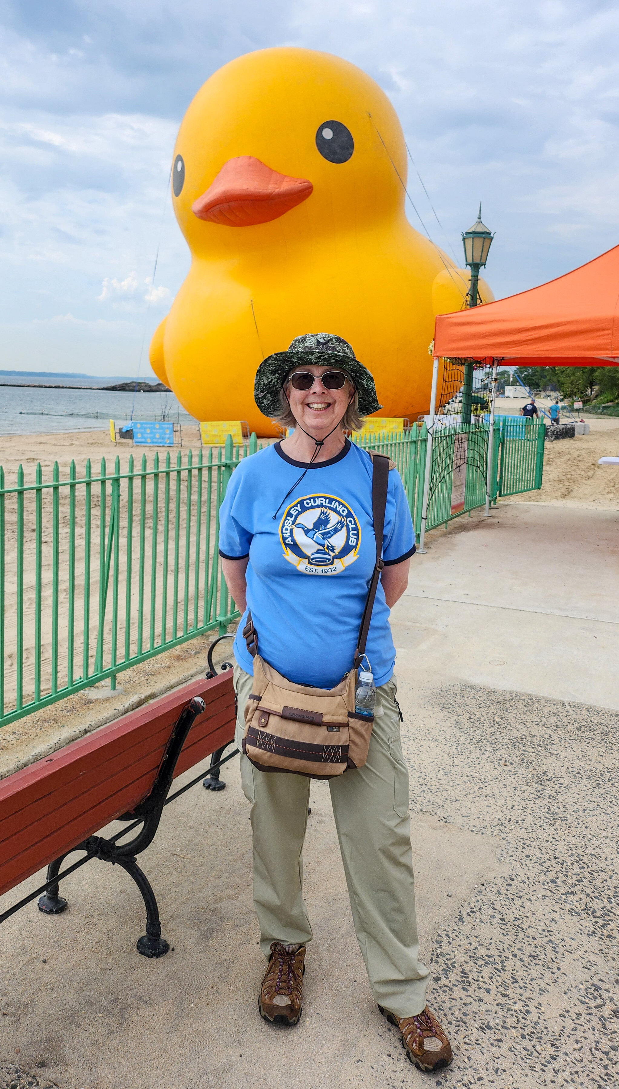
I got home in time to visit the World's Largest Rubber Duck in Playland. Not only did a visit to it fit with the theme of this trip, but it also can be a Duck of the Month for the Ardsley Curling Club Newsletter.