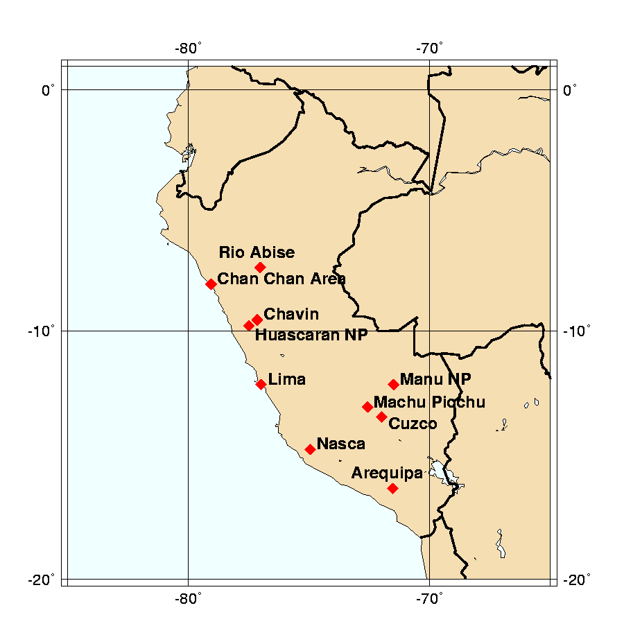

Dating from the 11th century, Cuzco was the capital of the Inca empire until Francisco Pizarro claimed it for Spain in 1534.

Known as the "Lost City of the Incas", the ruins of Machu Picchu were discovered in 1911 by Hiram Bingham.
Dating before 800 BC, these ruins reflect one of the earliest known Andean cultures. It is believed that Chavin was the center of a religious cult in which the jaguar is believed to have played an important role.
Huascaran National Park contains the Cordillera Blanca, the highest tropical mountain range in the world. Crowned by Huascaran at 22,205 feet, there are dozens of peaks of similar height. The Pyramid of Alpamayo is considered one of the most beautiful mountains in the world. The park is a paradise of deep glacial canyons, Andean flora and fauna, pre-Columbian ruins and turquoise lakes at the foot of the glaciers. Trekking routes range from easy two-day walks to one to two-week hikes criss-crossing the high passes of the Cordillera.
Much of the park is rugged and inaccessible leading to a host of diverse flora and fauna. As much as 10 percent of the botanic species within the park are as yet unknown to science. Several indigenous Indian populations including the Machiguengas and the Kogajakoris have had very little contact with outside civilisation.
This was the capital of the Chimu civilisation. The Chimu preceded the Incas who conquered them in 1465-1470.
Locally known as La Selva, the park is home to a number of endemic species. The yellow-tailed wooly monkey was thought to be extinct, but is found only in this area. In addition to flora and fauna, the park contains numerous important archaeological sites.
The former Convent Ensemble of San Francisco de Lima is included in the Historic Centre of Lima.

The Nazca culture flourished from the 2nd century BC to the 7th century AD when it was superseded by Huari and then Inca. The area is noted for "Nazca lines," some of which were revealed in aerial observations to be outlines of huge animals traced on arid tablelands. They were discovered by Dr. Paul Kosok of Long Island University. In 1946 he passed all of his information to Maria Reiche, a graduate of Hamburg University. She became the protector, preserver, and interpreter of the drawings for 50 years.
The 5000-year-old city is situated on a dry desert terrace overlooking the green valley of the Supe river. It is the oldest center of civilization in the Americas, dating back to the Late Archaic Period of the Central Andes. Features include complex and monumental architecture, including six large pyramidal structures. A quipu (the knot system used in Andean civilizations to record information) found on the site testifies to the development and complexity of Caral society.
Joint listing with Argentina, Bolivia, Chile, Colombia, Ecuador, and Peru. This site is a network of roads constructed by the Incas over several centuries covering 30,000km and includes 273 component sites. The network links the snow-capped peaks of the Andes at an altitude of more than 6,000 m to the coast, running through hot rainforests, fertile valleys and absolute deserts.
This is a prehistoric site (250-200 BC), located in the Casma Valley, comprising a set of constructions in a desert landscape that, together with natural features, functioned as a calendrical instrument, using the sun to define dates throughout the year.
Lynn Garry Salmon <>{
Last updated: August 13, 2021