


The 7 sq mi (17.2 sq km) area is bounded by the Golden Horn to the north, the Bosphorus to the east, the Marmara Sea to the south and land walls to the west. The following four areas have been particularly singled out for conservation:
Links with more information:
A region in Central Anatolia that offers a lunar-like landscape. In the valleys, stones and rock formations in the shape of mushrooms called fairy chimneys stand out in an amazing landscape.
Once a Byzantine outpost, Divrigi became the capital of the Turkish Mengucek Emirs in the 12th and 13th centuries. Visitors come to Divrigi to see the Ulu Mosque and Medrese of 1229.
Impressive double walls, in which are set the Royal Gate, the Lion Gate and the Yer Kapi (an underground tunnel), ring the Hittite city of Hattusas, known today as Bogazkale.
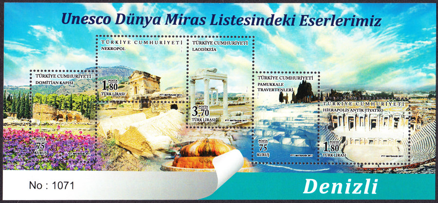
A spectacular and magical site. Snow white lime stones with springs of thermal water have been considered theurapetic since the time of the Romans.

Troy is one of the most famous archaeological sites in the world. It was first excavated by archaeologist Heinrich Schliemann in 1870. Its extensive remains are the most significant demonstration of the first contact between the civilizations of Anatolia and the Mediterranean world, and the siege of Troy by Spartan and Achaean warriors from Greece in the 13th or 12th century B.C. was immortalized by Homer in the Iliad.
Catalhoyuk is an example of a well-preserved Neolithic settlement. Excavations of the Eastern tell have revealed 18 levels of Neolithic occupation dating from 7,400 to 6,200 BC.
There are eight component sites in the City of Bursa and nearby village of Cumalikizik. It includes the tomb of Orhan Ghazi, founder of the Ottoman dynasty.
The acropolis crowns a landscape containing burial mounds and remains of the Roman, Byzantine, and Ottoman empires in and around the modern town of Bergama.
The fortified city of Diyarbakir is located in the Fertile Crescent along the Upper Tigres River Basin. It has been an important center from the Hellenistic period, through the Roman, Sassanid, Byzantine, Islamic and Ottoman times to the present.

The Ancient City of Ephesus is an outstanding example of a Roman port city. It comprises successive Hellenistic and Roman settlements founded on new locations, which followed the coastline as it retreated westward. Excavations have revealed grand monuments of the Roman Imperial period including the Library of Celsus and the Great Theatre. Little remains of the famous Temple of Artemis, one of the "Seven Wonders of the World," which drew pilgrims from all around the Mediterranean. Since the 5th century, the House of the Virgin Mary, a domed cruciform chapel seven kilometres from Ephesus, became a major place of Christian pilgrimage.
The capital of the Bagratid Armenian kingdom that covered much of present-day Armenia and eastern Turkey had its heyday in the 10th-11th century. This ruined medieval settlement was a commercial center on the Silk Road and other trade routes into Anatolia.
All the structures at Ani are constructed using the local volcanic basalt, a sort of tufa stone which is easily carved. Notable remaining buildings include the Cathedral, the church of St Gregory of Tigran Honents, the citadel and the mosque of Manuchihr. The nominated area also includes the rock-cut dwellings and monuments outside the city walls.
The listing includes the archaeological site of Aphrodisias and the marble quarries northeast of the city. The wealth of Aphrodisias came from the marble quarries and the art produced by its sculptors. The temple of Aphrodite dates from the 3rd century BC and the city was built one century later.

Turkish for "Potbelly Hill", Gobekli Tepe is an archaeological site in the Southeastern Anatolia Region. Built around 10,000BC, it predates Stonehenge by 6,000 years.
This 30 meter tall archaeological tell is located in the Malatya plain, 12 km south-west of the Euphrates River. Archaeological evidence from the site testifies to its occupation from at least the 6th millennium BC with the earliest layers from the Early Uruk.
A multi-layered ancient settlement, encompassing the remains of the ancient capital of Phrygia, an Iron Age independent kingdom.
Sardis was the capital of the Lydians, a powerful Iron Age civilization (8th-6th centuries BC) known for its wealth and early coinage production. The cemetery of Bin Tepe features some of the largest tumulus tombs in the world.
Lynn Garry Salmon <>{
Last updated: July 24, 2025