 by
John Salmon
by
John Salmon
by
John Salmon
by
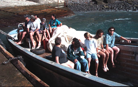
John SalmonCynthia called and said we're leaving at 2pm - marshall the troops. We show up at the dock at 2pm, but we don't get going for an hour. The longboat ride is quite a thrill. We don't go vertical the way the islanders did a couple of weeks ago, but crashing through the breakers is pretty exciting nonetheless.
The transfer to the Kialoa is again via a two-stage transfer. First we transfer from the longboat into a rubber dinghy, and then from the dinghy into Kialoa. The transfer from the longboat into the dinghy basically involves jumping from the rail of the longboat into the dinghy. The rough seas make this a slightly tricky operation, with the jump oscillating anywhere from about two feet to about 6 feet. I try to jump when the dinghy is at the top of it's oscillation, but I misjudge the timing, and my foot ends up slipping off the dinghy, and I go toppling into the water. Fortunately, I come up quickly, and easily swim clear of the longboat. Ed pulls me into the dinghy and I am wet, but otherwise unscathed.
Everybody else makes the transfer without incident. We also have a TREMENDOUS amount of stuff along. Frank is aghast at how much gear is up on deck. Ed and Graham have provisioned us with enough supplies to establish a scientific research station on Henderson. Somehow, we manage to stow it all in various places around Kialoa.
The run to Henderson is downwind and is much bumpier than the trip from Mangareva to Pitcairn. I have the first watch with Barry, who quickly succumbs to the rolling of the boat. Sitting outside helps, but Barry isn't feeling up to conversation. In fact, just about everyone is seasick before we start. We spend a while working with sails and stowing gear, and during that time we aren't moving, so the rocking of the boat is much worse. Frank describes the seas as "fairly rough" but certainly nothing to worry about.
Dinner is cooked on Kialoa's gimbaled stove. It's quite disconcerting to see it swaying violently back and forth with a large pot of stew sitting on the burner. It looks as though the stew should be flying out of the pot, but of course it's the boat's walls and floor that are moving and the stove is staying relatively still. There seems little rhyme or reason to the stew. The first few dozen or so items found in the stores get thrown into the pot and it all gets cooked up together. Spaghetti noodles, broccoli, canned baked beans, etc. Surprisingly, it comes out pretty tasty.
At 4am I'm awakened. I manage to fall on somebody as I make my way outside. It turns out that we're in the midst of a squall and the wind is shifting and Frank wants to jibe (which is like tacking, but downwind instead of upwind). He wants extra hands on deck who have at least a passing familiarity with boat operations and aren't green from seasickness. Ed is already outside with Frank. It's a sorry statement about the rest of the crew that I'm the next most qualified sailor. After the minor excitement of being on deck in a squall I go back to sleep and wake up early.
We swing around the east side of the island and get our first look at East Beach. Whoever it was that gave names to Henderson's geographical features was sadly lacking in imagination. Since we are in the lee of the island now, the seas are much calmer. It takes us a while to find a good anchorage because the digital depth sounder is not working, and the backup pen plotter based system is difficult to read and is close to running out of paper. We finally drop anchor in the early afternoon.
The wind has been shifting, and is threatening to come around from the east, which would make the east beach untenable. Access to Henderson's East Beach is through a narrow, poorly charted break in the very shallow and very sharp coral. It's best to make the attempt near high tide, and it's impossible near low tide. Thus, we can't just jump in the dinghy and make for land. If we land and the wind continues to shift around to the east over the next few hours, we could be effectively trapped, with no way back to Kialoa. There's simply no way we could make it over the coral in seas like those we saw crashing on the south side of the island.
And so we wait, and wait, and wait, a few hundred yards off shore, studying the sky, and watching the sea as it breaks over the coral, looking for the alleged opening. I take the opportunity to send an email congratulating my colleagues at the CACR on the dedication of a new supercomputer, which took place yesterday.
Ed has a map of sorts, drawn by Graham, which depicts a couple of caves (there are many visible on the cliff) one of which has a cross in it (also visible!). The location of the safe passage is shown with respect to the cross. It looks a bit like a treasure map from an old movie - scrawled in a shaky hand with undecipherable hieroglyphic writing. Ed seems confident he understands its meaning, and there should be nothing to worry about.
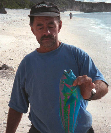
Keith decides to put the waiting time to good use and teaches Haron and Adrian how to fish. The fishing off Henderson is phenomenal. No sooner does a hook get dropped in the water than a brilliant red coral trout latches onto it and jumps into the boat. In fact, the fish are literally catching themselves - and when an unbaited line is accidentally left in the water overnight we wake up to find it with a 5 pound trevally. They must have caught about 20kg of fish, but there are eleven people along, and Kialoa has a freezer, so none of it is wasted. Ed and Keith demonstrate their proficiency with very large and very sharp knives, and do an expert job of cleaning. I eat a lot of fish over the next couple of days, and never once encounter a bone.
We make it over the breakers and onto the beach with only a couple of splashes and no real threat of being swamped. Ed spends much of the morning ferrying people and supplies from Kialoa onto the island. Eventually, all our stuff (sleeping bags, food, etc.) is safely on the beach and dry, and we haul the dinghy up well above the high tide line.
The east side of Henderson Island is an absolutely stunning white sand beach backed by coconut palms and pisonia facing a shallow reef and thousands of miles of deep blue Pacific Ocean. And it's absolutely covered with debris. Anything that floats and that doesn't deteriorate is washed up on Henderson Island's East Beach. Some things you might expect, like plastic buoys and netting, and ropes of all shapes colors and sizes. Some of the stranger items were a large assortment of Suntory liquor bottles, shampoo bottles and other plastic containers, a kerosene lantern, and even some intact light bulbs (both fluorescent and incandescent!). There was a very large meteorological buoy with a notice on it to please notify some oceanographic institute if it were found, but the address of the institute was obscured, and even the country of origin was impossible to determine (Spanish speaking). It appeared that the payload had already been removed, so whoever was interested in it has presumably already learned of its fate. There are also a lot of chunks of wax, ranging in size from a couple of ounces to about 50 pounds. I never figured out what they were, or where they came from.
Everyone but me seems to know about a major international trade in "glass buoys". People were talking about them all yesterday evening. Some were visible from Kialoa with the help of binoculars, and fights were almost breaking out over who had spotted them first. I can't even figure out what people are talking about until we land. Apparently, before plastic was commonplace, buoys and floats were often made of blown glass spheres. Some have an amazing longevity and drift around the globe, eventually washing up on places like Henderson after decades at sea. These glass buoys are of interest to collectors and antique dealers and are actually worth a few dollars if you have the right connections, it seemed like something out of a Pynchon novel. We find quite a few on Henderson, but the auction houses in Auckland and Raratonga will be disappointed because we left them behind, with Frank declaring, "We are not a salvage ship."
The first order of business once we reach shore is to prepare lunch. Cynthia fries lots of last night's catch of fresh fish. It's incredibly good just fried in oil in a cast-iron skillet over a wood fire with a little salt and pepper. In fact, I think it's the best fish I've ever eaten. Really. It's definitely better than most of the world heritage foods we enjoyed in the FNQ a couple of years ago.
After lunch, most of us spread out over the beach. Dalreen gets into beach combing for shells and finds a huge variety of multicolored shells, skeletons, and other parts. Ed readily identifies most of them, and frequently relates some interesting factoid or two about the the animal (or occasionally plant) that left the item behind. Dalreen eventually acquires a huge collection, most of which are banned from Kialoa because of the smell.
A hundred meters or so down the beach from our camp site there are a series of large bowl-shaped depressions in the sand, just short of the tree line. They are about 10 feet across and maybe a foot or so deep. They look like they might have been caused by small bombs. In fact, they are sea turtle nesting sites. There are no turtles at this time of year though.
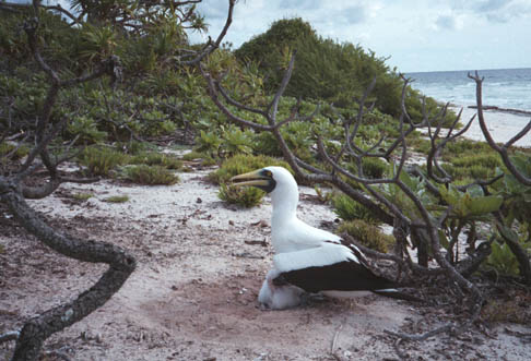
At the moment, the nesting inhabitants are the gannets (or boobies). They become distressed if approached too closely, but they do not flee. They just sit on their nest and squawk loudly. We try to give them plenty of room so as not to disturb them. In the days of Bligh and Christian, boobies were a source of protein on long sea voyages, and their tendency to sit still was not a beneficial survival trait.
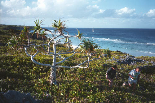
After lunch, we venture into the island's interior. This involves climbing a limestone cliff about 50 feet high. It's steep enough that it's a lot harder coming down than going up. The climb is difficult because the rock is really fossilized coral, and it isn't very solid. It breaks off easily, so one has to be careful about where one grabs for balance. It's also very sharp, so leather gloves would have been a big help. Several of us make it up the cliff face: Rob, Dalreen, Barry, Ed, Maddie and myself.
The interior of Henderson is beautiful, and shockingly inhospitable. It is covered by a dense thicket of waist-high-to-shoulder-high brush (pisonia). The brush is thick enough to make progress slow, but not quite impossible. On the other hand, it is thick enough to make it impossible to see the ground. This is important because the entire island is made of the same fossilized coral that comprised the cliff face. It's sharp, friable, and full of pot-holes, cracks, voids and depressions. It's almost impossible to make progress without staggering into a hole every few meters.
 [Ed and Maddie in the brush on Henderson]
We spend an hour or so up on top, and manage to walk maybe 500 meters along the edge of the cliff. Ed provides a running commentary on the plants and bird-life - interspersed with lots of odd-sounding bird-calls. I manage to see three of the four endemic bird species. I think Ed spotted all four, but I'm not sure. I have a hard time keeping track of the different petrels. Despite the difficulty, it's a terrific walk, and I have the same feeling of exploration that I've only had a couple of times before (Gaochang in China comes to mind). It feels like we are discovering the place for the first time. Of course many (well, at least a few) other people have been here, but right now, we're the only people for hundreds of miles, and we may be the only people to visit this particular part of the island for many months or years.
The cliff face descent is steep and tricky. We pass quite close to a petrel's nest that's perched in the cliff, and the resident petrel makes it quite clear that we aren't welcome guests. Dinner is spaghetti and baked beans cooked over a wood fire. Firewood, at least, is plentiful. The pisonia breaks easily and burns well. Fresh water, on the other hand, is scarce. There is no supply on the island, but we have several large barrels of water with us, so we will not go thirsty.
After dinner, the kids head down the beach to sleep in one of the many caves. Word has it that one of them has "dead bodies" in it, and they plan to sleep in that one. That turns out to be just a little too creepy, and they end up in another one.
It's another beautiful day, and the tide is fairly high right after breakfast (more World Heritage fish -- yumm), so I go snorkeling. The snorkeling here is even better than at Aukena. There are lots and lots of fish of all shapes and sizes. I see a couple of fairly large parrot fish. When I return to the beach I discover that Adrian has chummed the water with some of the offal from yesterday's fish-cleaning operation. This has attracted a small shark and a few larger fish into the shallow reef area. The 1 meter shark cruises around the beach for a while and makes me a bit nervous about further snorkeling. In fact, there's probably nothing to worry about, as small sharks like this one never attack people. That's all well and good in theory, but it's a different matter when you actually see the beast in the water in front of you.
In 1991-92 the Sir Peter Scott Commemorative Expedition to the Pitcairn Islands carried out a yearlong scientific study of the natural environment on Henderson Island. The findings were published in
Benton, T.G. and T. Spencer, Editors. PITCAIRN ISLANDS, biogeography, ecology and prehistory, Academic, 1995, ca. 420 pp., illustrations.To facilitate that study, several paths were cut across the interior of the island, including one from East Beach to North Beach. Obviously, the trail hasn't been maintained in the years since it was cut, but we don't expect the vegetation to grow back that fast. After all, Henderson doesn't get that much rain, and the earth is not particularly fertile. Nevertheless, we are unable to find anything that looks like the remnants of a trail after several hours of searching. One problem is that we don't have an accurate map. We do have a book based on the 1991-2 expedition, and the cover photo was obviously taken from the top of the cliff above the north end of East Beach. We start our search from the point at which the photo was taken, on the dubious assumption that the photographer was standing at the trail head to take the picture.
All our searching is to no avail. Keith even tries to hack a new trail through the bush. Keith's the kind of guy who doesn't just carry a machete. He finds occasion to use it! Even the Crocodile Man is thwarted by the interior of Henderson Island, which makes me think that our 500m walk along the cliff-tops yesterday only gave us a taste of how impenetrable the interior really is.
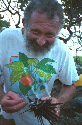 [Ed Saul serving sex organs from a fresh sea urchin]
While we are preparing dinner an extremely bold bird (I think it was
the Henderson rail, one of the endemic species) marches through our campsite.
We have also been sharing our campsite with the ubiquitous Henderson crabs.
Tonight's dinner is a hearty chowder made from local delicacies. Ed's
basic approach to "bush tucker" is that if the Maoris had a name for
it, then it must be edible - otherwise why would they have bothered to name it?
The chowder includes both giant clams and sea urchin. The clams are about
six inches across and have brightly colored (almost fluorescent) mantles.
The mantle isn't the edible part though. Dalreen is given the task of
cleaning the clams and is handed a hardhat. She is somewhat mystified about
why she needs a hardhat to clean giant clams, but Ed explains that it's
an all-purpose tool and can be used as a bowl as well as protective headgear.
Ed also points out various internal organs as the clams are opened, which was
far more information than Dalreen really needed.
I always enjoy weird foods, and I'm not particularly squeamish, but I have
to confess that the sex organs from raw sea urchin, spooned directly out
of the shell is pretty close to my limit.
Ed also enjoys a giant escargot - cooked in the shell.
After dinner, we go lobster hunting, but come up empty-handed. The
Pitcairners tell us that at low tide during a full moon you can just
walk out on the reef and reach down and pick up lobster. We have low
tide, but no moonlight, and we don't spot any lobsters. The earlier shark
sightings continue to make me nervous too, and it's getting chilly wading
out into the surf.
Keith has also spent the afternoon assembling a lobster trap from some
debris that washed up on the beach. He baits it with offal from yesterday's
fish catch, and weights it with some rocks and leaves it out in the surf.
We hope to wake up to a lobster breakfast.
Today's project is to get to North Beach. Since the overland route
proved impassable, the plan is to approach by sea. We spend the morning
ferrying our gear back to Kialoa. When that's accomplished, we board
the dinghy again and motor around
to North Beach. It's a long and wet trip in the dinghy in
fairly rough seas. We get tossed around quite a bit, and Ed reiterates
the instruction to stay with the dinghy in case we are swamped.
This time the safe passage over the coral is marked by a stand
of coconut palms, and again we land safely. Ed goes back to get the
rest of the group, and we do some beach combing on North Beach.
North Beach is remarkably different from East Beach. For one thing,
there is far less debris washed up here. There are a few bits and pieces
of plastic, but they do not form an overwhelming first impression.
Also, at the water's edge there is a wide swath of stone that
apparently forms when rainwater leaches minerals out of the rock on the
island, which then precipitates out when it hits the ocean.
There are lots of little tidal pools, but the sea is too rough and variable
to support the delicate tidal fauna that one sometimes finds in tidal pools.
We also find a bronze plaque declaring Henderson a
World Heritage Site, and
admonishing visitors to leave its natural beauty intact. This is the
site of the main encampment of the 1991-92 expedition. Lunch consists of
cheese and crackers (our supplies are dwindling) and some fresh coconut
(again thanks to Keith and his machete).
We also finally find some miro-wood. This is the wood used by
the Pitcairners in their carvings. All the stands that
are easily accessible from the beach have been heavily harvested.
There is a project going on now to try to propagate miro-wood on Pitcairn
itself so that less pressure is placed on the Henderson supplies.
It is starting to get dark as we return to Kialoa.
While we were
beach combing, Kialoa sailed around the point, and is now waiting
for us right off North Beach. The wind has started to blow, and the
seas are quite rough, which makes the transfer from the dinghy to
Kialoa difficult. One essentially has to jump from the dinghy at
the top of an oscillation and grab onto Kialoa's railing.
It's a tricky maneuver, and none of us manages
it terribly gracefully. Maddie loses her balance and a couple of us
grab her to keep her from going in. During the struggle, Frank injures
his thumb.
The sail back to Pitcairn is uneventful, except that almost everyone
is seasick again (except for Frank, Ed and myself). We sail directly
for Pitcairn, and arrive early the next morning.
Follow Lynn back on Pitcairn Island
or
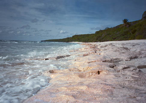 [North Beach, Henderson Island]
June 15 (Henderson Island, North Beach)
But alas, the lobster trap wasn't sufficiently weighted down, and the surf
pushed it up on the beach before any of our edible friends found it.
Breakfast is peanut butter on crackers instead. Keith is confident
that if we had another evening, he'd have the bugs worked out of the
technology, and we could dine on lobsters for sure.
