

The home to the Royal Family since 1981. The castle was designed by architect Nikodemus Tessin the Elder. It is located on an island in Lake Malar in a suburb of Stockholm.
In Lake Malar, Birka (located on Bjorko Island) was the first major Swedish urban center and an important early Viking trade center as the Baltic link through Russia to the Byzantine Empire until 975 AD. It declined because the water level dropped and Gotland took over the Russo-Byzantine trade. Hovgarden is on the neighboring island of Adelso and also influenced the trading networks of the Viking-age.
Sweden has been a leader in production of superior grades of iron, and this site is the best-preserved and most complete example of the early industrial era.
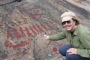
The Bronze Age rock carvings in Tanum, in the north of Bohuslan date from 1800 B.C. The carvings are in an area intensively occupied by a farming and fishing society, and the range of motifs provide exceptional evidence of many aspects of life in this period. The site complements an existing World Heritage rock carving site in Norway (Alta), representing a hunter-gatherer community.
This cemetery in Stockholm was built between 1917 and 1920 by two young architects, Erik Gunnar Asplund and Sigurd Lewerentz.
A former Viking site on the island of Gotland, Visby was the main center of the Hanseatic League of the Baltic from the 12th to the 14th century.

The Lapponian Area lies in the Arctic Circle region of northern Sweden. It is the home of the Saami people who maintain their ancestral way of life based on the seasonal movement of herds of reindeer.
Located at the head of the Gulf of Bothnia, Gammelstad is the best preserved example of a church town. It was only used on Sundays and religious festivals to lodge worshippers who came in from the surrounding countryside and who could not return home in a single day because of the distance and difficult travelling conditions.
Karlskrona is an exceptionally well preserved example of a 17th century European planned naval town.
The High Coast is located on the west shore of the southern Gulf of Bothnia, a northern extension of the Baltic Sea. In 2006 the site was extended to include the Kvarken Archipelago area of Finland.
Southern Oland is an outstanding example of human settlement. Human beings have lived here for some five thousand years and adapted their way of life to the physical constraints of the island.

The Falun landscape is dominated by the remains of copper mining and production, which began as early as the 9th century and came to an end in the closing years of the 20th century. It was for centuries one of the world's most important mining areas.
 (57.113 N 12.402 E) --
satellite image
(57.113 N 12.402 E) --
satellite image
Less than 100 years ago, wireless communication demanded gigantic technical equipment. The Grimeton Radio Station, built near Varberg in 1924, is the last remaining operational mechanical broadcasting station in the world. It functions completely without electronics - they had not yet been invented.
Joint listing: Belarus, Estonia, Finland, Latvia, Lithuania, Norway, Republic of Moldova, Russian Federation, Sweden, Ukraine
The Struve Arc is a chain of survey triangulations running through ten countries and over 2,820km from Hammerfest in Norway to the Black Sea. The survey was carried out between 1816 and 1855 by the astronomer Friedrich Georg Wilhelm Struve, and represented the first accurate measuring of a long segment of a meridian. 34 of the original 265 station points are included in the listing.
See Belarus listing for more information.
Seven timber houses are listed in this site located in the east of Sweden, representing the zenith of a regional timber building tradition that dates back to the Middle Ages.
Lynn Salmon <>{
Last updated: July 12, 2021